
Primary Sources: Maps & Newspapers
Maps
The State Library has an extensive collection of historical Florida maps, including many from the territorial period. Below are selected examples:
- de Beaupre. Floride. Paris: Gravé par B. de Beaupré, 1825.
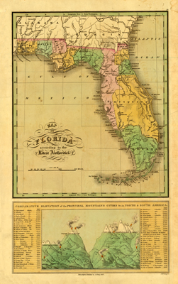
- Finley, Anthony. Map of Florida According to the Latest Authorities. Philadelphia: A. Finley, 1827.
- Hutchinson, Charles. Plan of Tallahassee. Tallahassee: Charles Hutchinson, 1840.
- Illman & Pilbrow. Map of the Territory of Florida. New York: Illman & Pilbrow, 1834.
- Mackay, John. Map of the Seat of War in Florida. Tampa Bay, Fla. : Head Quarters, Army of the South, 1839.
Hundreds of the State Library’s historical Florida maps have also been digitized and added to Florida Memory. Of those, 37 maps are from the territorial period.
Image: A. Finley. Finley's Map of Florida. 1827. State Library of Florida, Florida Memory.
Newspapers
Researchers will find a number of digitized newspapers from the territorial period through the University of Florida’s Florida Digital Newspaper Library database.
In addition to what is available online, the State Library’s collection includes newspapers from the territorial period both on microfilm and in physical format.
Below are selected examples:
- Apalachicola Courier. Scattered issues on microfilm and loose issues, 1839-1840.
- Apalachicola Gazette. Microfilmed issues and loose issues, 1836-1840.
- Joseph Times. Scattered issues on microfilm and loose issues from 1838-1841.
- Florida Sentinel. Scattered issues on microfilm 1841-1860.
- Florida Herald. Scattered issues on microfilm and loose issues, 1829-1848.
Researchers can find additional newspapers on microfilm and in physical format from other repositories through the Florida Digital Newspaper Project database.