What we do
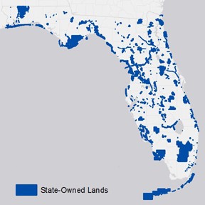
The Bureau of Archaeological Research has surveyed over 1,000,000 acres of State-owned lands in Florida to locate archaeological and historical sites.
Public Lands Archaeology Surveys
Since 1989, the Division of Historical Resources’ Public Lands Archaeology (PLA) program, formerly the Conservation and Recreation Lands (CARL) archaeology program, has worked with state land managers and other agency personnel to inventory and evaluate archaeological and historical sites on conservation lands. The primary responsibilities of Public Lands Archaeology are to conduct cultural resource surveys on state-owned lands and provide management recommendations to the Florida Forest Service, the Florida Fish and Wildlife Conservation Commission, the Florida Park Service, and the Florida Coastal Office (State land managing organizations). PLA also provides management assistance to state agencies through conducting damage assessments in response to unauthorized excavation, managing discoveries of unmarked burials, leading training courses for cultural resource management, providing interpretive material for cultural sites, and reviewing management plans.
Goal and Objectives
The goal of the program is to help land managing agencies of the state steward cultural resources on their properties, and to increase public awareness and appreciation for Florida’s cultural resources. This is accomplished through several objectives:
- Conduct cultural resource inventories and assessments on state-owned lands. The purpose of investigations is to locate undocumented sites, revisit known sites, and provide management recommendations. As part of assessments, PLA staff generate reports in accordance with Chapter 1A-46, Florida Administrative Code and update the Florida Master Site File.
- Provide input on land acquisition proposals and review management plans by staffing the Acquisition and Restoration Council (ARC) for the Division of Historical Resources.
- Promote and coordinate education, research, and outreach on archaeological and historical sites in Florida.
- Assist with preparation of archaeological site nominations to the National Register of Historic Places.
- Present and publish results of PLA projects for avocational and professional audiences.
- Lead training courses designed for land managers and law enforcement personnel.
Accomplishments
Between 1990 and 2014, PLA (CARL) program staff surveyed 1,268,249 acres of land on 273 state-managed properties. As a result of PLA surveys, a total of 1,441 archaeological and historical sites have been recorded or updated. DHR has conducted large-scale salvage work or research at significant sites including Block-Sterns, Bulow Plantation, the DeSoto Site, Fig Springs, Fort George, Fort Foster, Itchetucknee Springs, Lake Jackson Mounds, Letchworth Mounds, Page/Ladson, Shell Bluff Landing, Waddell’s Mill Pond, and Wakulla Springs. Recently, PLA has produced atlases of sites on Aucilla River Wildlife Management Area, Big Bend Wildlife Management Area, and Charlotte Harbor Preserve State Park. Reports for all projects are available through the Florida Master Site File, the State of Florida’s official inventory of historical and archaeological resources.